Soft spoken and seemingly a little shy, but very confident speaking about the field of research he is involved in. Though indistinguishable from other youths by looks or style, hidden inside him is genius. Enthusiastic about his project in developing algorithms to measure minimal displacement of soil from an area, Amila Thilanka Karunathilake, is the winner of the “Young Scientist Award -2017” for Geo Science and Remote Sensing, from the prestigious Institute of Electrical and Electronics Engineers, Japan Council.
 Amila Karunathilake who hails from Kandy had had his initial education at Dharmaraja College. He graduated with Honours in Physics and completed his Master’s in Science, researching geographic information systems (GIS) and remote sensing, close home at the University of Peradeniya. Armed with a scholarship from the Japanese government, he entered the Graduate School of Environmental Studies at the Tohoku University, Sendai, Japan for doctoral studies. “After completing my Master’s degree, I read many articles related to remote sensing published by world-leading research groups. I wanted to join one of them to learn something new which I could not learn in Sri Lanka.
Finally, I was lucky to be selected by one of the world-leading research groups specialized in radar remote sensing,” a jubilant Karunathilake smiles, “the day I was chosen the best doctoral student of the Graduate School of Environmental Studies, was one of the happiest days of my life.” But, what propels someone to specialize in the field of environment science turning from a seemingly unrelated field of physics? The secret lies in his background, especially, in his alma-mater, declares a grateful Kaunathilake. “I’m a naturalist from the bottom of my heart. I was fortunate to study at Dharmaraja, situated at a scenic location in Kandy. Moreover, being involved with boy scouts in school - hiking, camping and the like, earned me a Scouts Wood Badge leading to the Presidents Award and deepened my love and respect for the environment.”
However, love for the environment seems to be a trait in his family. With the backing of his “very supportive mother who provides great motivation,” both, Karunathilake and his sister settled on environment as the field of study.
Moreover, landslides in the Kandy district had been the ground behind his choice. “People suffer from landslide problem in my hometown. It becomes a disaster due to lack of knowledge and understanding of the problem,” says Karunathilake. When he had to opt for a field of specialization he chose to specialize in Ground Based Synthetic Aperture Radar (GBSAR).
Radar systems were first introduced during World War II for military combat. Its potential use in weather monitoring was recognized and put into use as early as the 1950s.
Radars are used in environment monitoring in three different ways, space borne (satellites), ground penetrating radars and ground based radar.
Though Synthetic Aperture Radar (SAR) system which creates two- or three-dimensional images of objects, such as, landscapes is a basic mode, the ground based system is a fairly ‘new’ introduction.
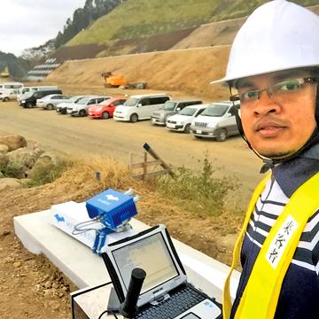
 The ground based radar Karunathilake preferred to work on was a system monitoring displacement of soil from identified areas.
According to Karunathilake, the system for which he developed algorithms, could identify 0.8mm (zero point eight millimeter) displacement from a distance of four kilometers at real time. A team from Tohoku University, including Karunathilake had applied the system in several locations in Japan for the last 5 years.
Kumamoto, Japan, where large landslides are triggered by earthquakes is an area where Karunathilake had worked extensively.
“During the reconstruction period the stability needed to be measured for further threats. The radar system generated a data set every 10 seconds and a map every 15 minutes. This (the data) was connected to an alarm system which warned the workers.” The work had to stop and the workers evacuated several times, he says.
However, due to the system’s effectiveness lives as well as equipment were saved.
Present measurement systems used in Sri Lanka to envisage landslides is mechanical and arduous.
Once an area is identified hazardous, the official from the National Building Research Organization (NBRO) the competent authority on landslides have to be in the area physically, to get the necessary data to measure stability and issue specific forecasts.
However, with GBSAR a “very large area could be monitored remotely. Two dimensional maps could be generated at frequent intervals which could help identify the displacement as well as stable areas.
This helps to quantify displacement with precision improving the quality of forecasts.
Furthermore, it is real-time measurement, we can ascertain the displacement within 10 seconds from its happening.” Karunathilake opines that if such a system is applied in Sri Lanka, it could minimize considerable damage and save many lives.
The system enables measuring minimal movements remotely in a large area. The speed, extent and inclination of movement are some of the indicators measured in helping early warning. Karunathilake’s algorithm developments and simulation models in this area was what won him the ‘Young Scientist Award’ of the year.
“I am ready to share the knowledge, experience and best practices with any organization involved in the same field. As a Sri Lankan, I want to serve my country. ”