 The Northern most point of the Puttalam District, referred to as Kudiramalai Point, boasts a subtle fascination of its own. From its reddish earth and deep blue ocean, to the landscape jutted with unique reddish rock formations, it provides a vista that is both, memorable and curious. Added to this, the cape is richly woven with events of historical and legendary significance. Due to its geography, it has served as an important port in the past. This was the ancient Thambapanni, where prince Vijaya and his followers landed. This has also been the Kingdom ruled by ancient queens, including Kuweni and Queen Alli Arasani.
The journey to Kudiramalai Point lies through the Western border of the Wilpattu National Park. The journey began from the Eluwankulama entrance to the Wilpattu, on a safari jeep along the red road which unfolded through Wilpattu. On the bumpy ride through the outskirts of Wilpattu, many a wild animal reigned majestically in their selected abodes. The first greetings to the wild came from a crested hawk eagle, perched regally on a tree branch. Then a peacock danced in the sun, with its fan glinting bronze in the golden sunlight. Pink , purple and white wildflowers bloomed all over the place. The vast marsh land, dotted with tall trees emerging randomly from water, stretches to the far horizon, bordered by a wall of tall trees.
Lush green grasslands with lakes glinting blue in the distance was a common sight. The breeze was cool and soothing even during midday, despite the sun that glared down. There were butterflies and dragonflies fluttering in the wind. Spotted deer peeped through the shrubbery forest, towards the lakes.
The point of vantage
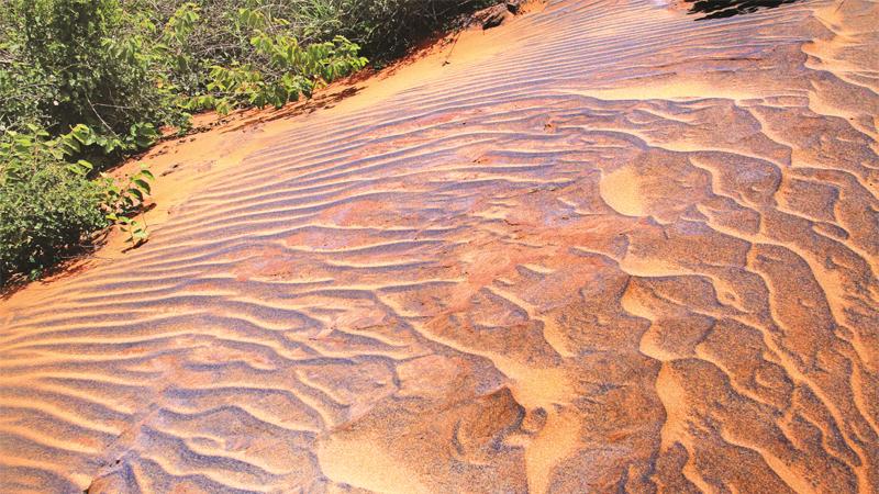
 Turning towards Kudiramalai, the forest grows denser and the redness of the sand becomes more evident. Before the road opens out to the Point, there is a small hillock formed by the accumulation of reddish bronze sand. There in the sunlight, the red sand glinted bronze than anywhere else, reminding one of the lore surrounding the landing of prince Vijaya, where the palms he placed on the beach glittered copper, hence leading to his naming the port town as Thambapanni.
It was a small climb up the hill, made slightly difficult by the fact that loose sand kept coming off. At other times the foot sunk in the sand. Once the hill top was reached, it proved to be a point of vantage with a panoramic view of green trees, of the beach that was stretching to infinity from one side and of the Battalangunduwa and other islets in the far sea. It proved more challenging to climb down the hill than to climb up, due to the difficulty in finding sure footing in the loose sand.
The shrubbery forest opens out to a cliff edge, right at Kudiramalai point. This is one location where everything that meets the eye fills one with wonder and awe. Beyond the cliff edge was the aquamarine sea, with waves splashing onto the cliff wall, providing a spectacular view. On the other side, the landscape of the earth, immediately leading up to the cliff edge, included rocky structures jutting out from the earth, with a few bushes growing among them. These rocky structures had a bluish grey surface on the top and a reddish surface beneath.
When traversing down a footpath winding through the rocky landscape, a similar sight meets the eye. On the hillside, the eroded soil has the appearance of having sprung up from the earth. There was also jutted out piles of what seemed to be clay, of a darker brown, and a softer texture than the rocky structures encountered earlier.
Speaking on these structures, Geological Survey and Mines Bureau, Director General, Prof. Rohan Fernando said, these formations are the bedrock, i.e., the solid rock layer which is beneath the soil layer. “They are the result of deposits formed on a continuous basis, due to wind action ( aeolian) and chemical weathering. These types of aeolian deposits are formed since this region of the country is not heavily affected by either, south-western monsoons or northeast -monsoons,” Prof. Fernando said.
He went on to explain that the reddish colour of these rock formations is due to the gravel of the area being rich in iron. “The lower most parts of these formations contain ferrous, that is, iron that has not been oxidised, giving the soil its deep red colour. The brownish rock formations consist of oxidised form of iron, known as ferric,” he said.
Prof. Fernando added that this type of aeolian deposits is unique to the area, while different types of aeolian deposits are formed all over the country.
“These were formed about 2 billion years ago, which is quite recent when geological time scale is considered,” he said.
Meteor
Speaking of the bluish grey layer found on the harder rock formations, Prof. Fernando said, the colouring is generally given by the presence of dolomite in the soil. “In the recent past, it has been found that certain heavy minerals exist in the soil of Kudiramalai,” Prof. Fernando added.
University of Colombo, Department of Physics, Prof.Chandana Jayaratne said, the type of soil in the Kudiramalai area indicates that this is a place where a meteor has fallen in the past. “However, not much research has been done in this area. Hence there is no proven evidence on this,” he said.
Rich in history
Once past the rocky formations, the shrub forest can be entered again, this time, on foot. A small walk beneath the canopy formed by trees brings one to the vicinity of some ancient ruins, where only a few stones at the base still remain.
There are a few beliefs as to what these ruins are. Some believe these are ruins of an ancient Hindu temple, while others believe they are the ruins of a statue representing a horse and a man. The horse statue is considered to have stood 35 feet high, with one of its front legs pointing skywards. Beside the horse was a man holding the reins.
It is believed, the cape has once been referred to as the horse hill. As per legend, Queen Alli Arasani had ruled this region in the classical period. She was known for her beauty and for her affinity for pearls found in the famed pearl banks of the Mannar region. It was said, she had traded these pearls for horses from Arabs at the cape, giving Kudiramalai the name “Horse Hill”.
As per the evidence of the remains of clay pots, Kudiramalai had been populated from the Mesolithic period. The Roman historian Pliny has recorded that during the reign of Emperor Claudius, a Roman tax collector known as Annius Placamus was blown off his course due to a storm and landed in the Kudiramalai harbour, between 44 to 55 AD. King Chandamukasiva, the ruler of Sri Lanka at the time, had seized the ship initially, but later on had welcomed Placamus with due courtesy and entered into a trade agreement with the Romans.
It has been recorded that a team of envoys consisting of four dignitaries was dispatched to Rome for this purpose. Pliny has referred to Kudiramalai harbour as Hipporus in his records.
French Biblical scholar Samuel Bochart was of opinion that the port Tarshish referred to in the Old Testament of the Bible, as a port from where gold, pearl, and ivory and peacocks were traded during King Solomon’s period, is Kudiramalai.
Closer to the beach, the significant red colour of the sand recedes, giving in to sand that is black and grey in colour. On one side of the beach is the calcium carbonate reef. “This limestone basin was formed after Sri Lanka and India separated into two lands, as a result of teletonic action, about 50 million years ago,” said Prof. Fernando.
In the ancient past, Kudiramalai has been the grounds to a beehive of activities. Today, it is less illustrious and remains a serene remainder of the past, where the notorious prince Vijaya, banished from his motherland, washed ashore in the ancient harbour in 543 BC, leading to the subsequent founding of the Sinhalese race.