“If we don’t have it, we don’t need it,” pronounces Daniel Fagre as we throw on our backpacks. We’re armed with crampons, ice axes, rope, GPS receivers, and bear spray to ward off grizzlies, and we’re trudging toward Sperry Glacier in Glacier National Park, Montana. I fall in step with Fagre and two other research scientists from the U.S. Geological Survey Global Change Research Program. They’re doing what they’ve been doing for more than a decade: measuring how the park’s storied glaciers are melting.
So far, the results have been positively chilling. When President Taft created Glacier National Park in 1910, it was home to an estimated 150 glaciers. Since then the number has decreased to fewer than 30, and most of those remaining have shrunk in area by two-thirds. Fagre predicts that within 30 years most if not all of the park’s namesake glaciers will disappear.
“Things that normally happen in geologic time are happening during the span of a human lifetime,” says Fagre. “It’s like watching the Statue of Liberty melt.”
Scientists who assess the planet’s health see indisputable evidence that Earth has been getting warmer, in some cases rapidly. Most believe that human activity, in particular the burning of fossil fuels and the resulting buildup of greenhouse gases in the atmosphere, have influenced this warming trend. In the past decade scientists have documented record-high average annual surface temperatures and have been observing other signs of change all over the planet: in the distribution of ice, and in the salinity, levels, and temperatures of the oceans.
“This glacier used to be closer,” Fagre declares as we crest a steep section, his glasses fogged from exertion. He’s only half joking. A trailside sign notes that since 1901, Sperry Glacier has shrunk from more than 800 acres (320 hectares) to 300 acres (120 hectares). “That’s out of date,” Fagre says, stopping to catch his breath. “It’s now less than 250 acres (100 hectares).”
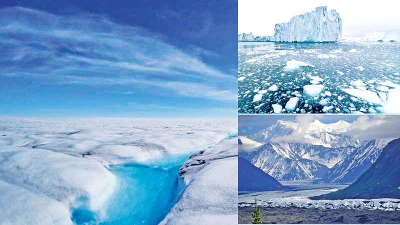
Everywhere on Earth ice is changing. The famed snows of Kilimanjaro have melted more than 80 percent since 1912. Glaciers in the Garhwal Himalaya in India are retreating so fast that researchers believe that most central and eastern Himalayan glaciers could virtually disappear by 2035. Arctic sea ice has thinned significantly over the past half century, and its extent has declined by about 10 percent in the past 30 years.
NASA’s repeated laser altimeter readings show the edges of Greenland’s ice sheet shrinking. Spring freshwater ice breakup in the Northern Hemisphere now occurs nine days earlier than it did 150 years ago, and autumn freeze-up ten days later. Thawing permafrost has caused the ground to subside more than 15 feet (4.6 meters) in parts of Alaska. From the Arctic to Peru, from Switzerland to the equatorial glaciers of Man Jaya in Indonesia, massive ice fields, monstrous glaciers, and sea ice are disappearing, fast.
When temperatures rise and ice melts, more water flows to the seas from glaciers and ice caps, and ocean water warms and expands in volume. This combination of effects has played the major role in raising average global sea level between four and eight inches (10 and 20 centimetre) in the past hundred years, according to the Intergovernmental Panel on Climate Change(IPCC).
Scientists point out sea levels have risen and fallen substantially over Earth’s 4.6-billion-year history. But the recent rate of global sea level rise has departed from the average rate of the past two to three thousand years and is rising more rapidly—about one-tenth of an inch a year. A continuation or acceleration of that trend has the potential to cause striking changes in the world’s coastlines.
Driving around Louisiana’s Gulf Coast, Windell Curole can see the future, and it looks pretty wet.
Rising sea level, sinking land, eroding coasts, and temperamental storms are a fact of life for Curole. Even relatively small storm surges in the past two decades have overwhelmed the system of dikes, levees, and pump stations that he manages, upgraded in the 1990s to forestall the Gulf of Mexico’s relentless creep. “I’ve probably ordered more evacuations than any other person in the country,” Curole says.
The current trend is consequential not only in coastal Louisiana but around the world. Never before have so many humans lived so close to the coasts: More than a hundred million people worldwide live within three feet (a metre) of mean sea level. Vulnerable to sea-level rise, Tuvalu, a small country in the South Pacific, has already begun formulating evacuation plans. Megacities where human populations have concentrated near coastal plains or river deltas—Shanghai, Bangkok, Jakarta, Tokyo, and New York—are at risk.
The projected economic and humanitarian impacts on low-lying, densely populated, and desperately poor countries like Bangladesh are potentially catastrophic. The scenarios are disturbing even in wealthy countries like the Netherlands, with nearly half its landmass already at or below sea level.
Rising sea level produces a cascade of effects. Bruce Douglas, a coastal researcher at Florida International University, calculates that every inch (2.5 centimetre) of sea-level rise could result in eight feet (2.4 metre) of horizontal retreat of sandy beach shorelines due to erosion. Furthermore, when salt water intrudes into freshwater aquifers, it threatens sources of drinking water and makes raising crops problematic. In the Nile Delta, where many of Egypt’s crops are cultivated, widespread erosion and saltwater intrusion would be disastrous since the country contains little other arable land.
(to be continued)
- National Geographic