It seems that Sri Lanka’s skyline is going through a whirlwind of change and so is the transformation taking place on its terra firma, with new highways, waterways and reservoirs coming up at a rapid pace.
Within the Colombo megapolis alone, more than a dozen new skyscrapers will to be added to the city’s skyline which is going through an impressive transformation. Colombo and its suburbs are currently dotted with mega roadways and luxury building projects.
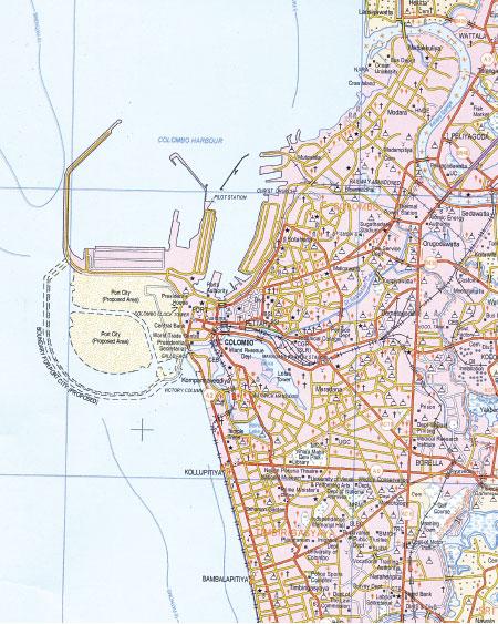
Updating maps
 To keep pace with this fast track development in the entire country the Sri Lanka Survey Department has decided to update its ‘digital’ topographic map every two years, ‘working on it every single day,’ Acting Surveyor General P.Sangakkara said.
Accordingly the 1:50,000 scale topographic map of the Survey Department, which used to be revised every five years, will be revised every 24 months.
The latest map containing Sri Lanka’s new contours defining the reclaimed land of the Colombo International Finance City (Port City) precinct will be out within the next three months, he said, announcing the exciting news to the general public for the first time.
The new Finance City, will add 660 acres to the existing land extent of the country.
Already 80 per cent of this project consisting of 92 maps, covering the entire country, is complete,” Senior Superinendent of Surveys, Mapping and Geographical Names Dr.Brian S. Rupasinghe who is in charge of the project said. He said five maps of the 92 are still in the process of being finalising.
 “This is an initiative to ensure that the Survey Department can provide the most accurate and latest data for the numerous service seekers who come to us on a daily basis,” he added.
These service seekers include construction industry staff, health and education officials, wildlife and forestry sector officers, members from schools and universities, diverse ministries such as the Megapolis to help plan their development projects and also the local and foreign tourists who wish to travel and see the beauty of our country.
“There are complaints that our data is not updated but our latest endeavour will address this issue as well,” he said. But the more detailed topographic map with a scale of 1:10,000 (eg. 1mm: 10,000mm) will be updated every five years as usual.
New topographic map
The new topographic map will cover seven areas of geographical and other features - water bodies, roads, land use patterns, place names (toponymy), contours, administrative boundaries and the national grid (the longitudes and latitudes).
Dr.Rupasinghe said that even the developed countries update the topographic maps between 2-5 years, hence, this exercise will bring Sri Lanka’s Survey Department one step closer to be on par with these countries.
The Survey Department, set up in August 1800 is the oldest Department in the country. Before N.S.Perera, the younger brother of LSSP stalwart Dr.N.M.Perera was appointed the first Sri Lankan Surveyor General in 1954, the Department had 21 British Surveyor Generals (SG). The Present Surveyor General P.M.P. Udayakantha who is abroad at present is the 47th SG.
In the good old days when the first complete map of Sri Lanka - famous map at the scale of one inch to one mile-was designed,the British surveyors camped at the surveying sites for months. They had workers stationed near the wadiya’to attend to their needs.
The method used then was the ‘plane table’ method, a combination of field observations and plotting, where the surveyors physically visited the sites to map the geographical features on the ground clearing the path as they proceeded.
It had been an effective method since there was no convenient mode of transport during this era , which was at the beginning of the turn of the century. “This map popularly known as the ‘One inch topographic map series’ was completed in 1924 after decades of ground surveys and is still considered a very accurate map,” the Senior Deputy Surveyor General (Mapping and Geo Names), Padma Kumara Withana said. The map consist of 72 sheets.
Modern tools
Today, with high resolution satellite imagery and aerial photography the task of the Survey Department has been made less complicated. However, it was revealed that due to lack of regular budgetary allocations from the Government to reinforce this particular sector, the mapping and constant updating of data has become an issue for Sri Lanka’s oldest and one of most important institutions. “There are special aircraft that can mount special photo equipment for gathering data, the camera we have now is highly outdated,” Dr.Rupasinghe said.
He said it was costly to maintain equipment hence the best option is to hire such facilities when the updating cycle of our topographic maps are due. To fill this void the Department uses Google data and direct satellite images at present.
The Survey Department maintains a map catalogue on their website, and there is a Special Mapping Branch to cater to the needs of the service seekers who need tailor-made maps. The schools make use of this service constantly to map houses around the school during grade one admissions.
The Department had an online service until recently to sell its maps, but due to lack of demand, the payment gateway had been shut down sometime back. ”We can re-open this service at short notice only if we get adequate online demands,” the Acting Surveyor General Sangakkara said.
Economic hub
Sri Lanka’s oldest department is getting ready to meet the evolving changes of the country as a tourism hub and an economic hub and other similar developments.
In keeping with this mission the Institution will also bring out a new road map and a tourist map, which will cater to the present day needs, covering the ATMs, gas stations including vehicle charging stations for hybrids and adventure parks marked as -air, ground and water adventure.