


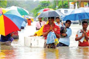
Severe floods that ravaged the districts of Colombo, Kalutara, and Gampaha on October 9 and later the districts of Galle, Kegalle, Kandy, Kurunegala and Ratnapura have caused devastation, displacing over 150,000 people, according to the latest official reports by the Disaster Management Centre (DMC).
The DMC reports added that 22,069 people from 5,349 families had already been affected, with one confirmed death as of October 12. The situation worsened over the following days, with 118,210 people from 30,017 families affected on October 13, and two more deaths recorded.
 On October 14, the number of those affected is recorded as 134,484 persons from 34,492 families, and the death toll was recorded as three. The most severe day was October 15, when 154,782 persons from 39,522 families were affected, and three lives were lost.
Despite a slight reduction in the floodwaters over the next few days, large numbers continued to be displaced.
On October 16, 137,792 persons from 35,391 families were impacted, with three more fatalities. On October 17, the number of affected were reported as 38,676 persons from 10,008 families, with two deaths.
On October 18 as reported by the DMC, the total number of affected personss was 15,838 from 4,388 families.
Long-term solution
This marks yet another instance in a recurring pattern of annual floods that have been affecting these regions, with little long-term solution. Given the gravity and regularity of these disasters, The Sunday Observer spoke to two key experts: Director of Irrigation (Hydrology and Disaster Management), Eng. S.P.C. Sugeeshwara and Senior Geologist Mahesh Somarathne, to explore the issues contributing to these events.
Eng. Sugeeshwara said that the floods were primarily caused by three main rivers: the Attanagalu Oya, the Kelani River, and parts of the Kalu Ganga.
The Department of Irrigation had issued warnings about the rising water levels 24 hours prior, ensuring that relevant district secretariats and the Disaster Management Centre (DMC) were notified well in advance.
“We mostly promote self-evacuation,” he said, adding that the first line of defence is making the public aware and encouraging them to move to safer areas. “We send the warning message to the DMC, which has its own mechanism to relay these warnings to administrative authorities, including the Grama Niladhari officers. From the village level to the District Secretariats, steps are taken.”
However, when people fail to evacuate on their own, the Government steps in. “Once our warning is issued, personnel, including the army, are mobilised to assist those who need help.” He said that, based on the current information, there has been no delay from the Government in issuing warnings and facilitating evacuations during the recent floods.
However, he acknowledged that controlling floods is a persistent challenge. “The common complaint is that flooded areas are not being protected from flooding. While floods cannot be entirely stopped, they can be controlled, but it comes at a significant cost.”
Flood-control mechanism
Reflecting on a 2017 proposal for a flood control system on the Kelani River, Sugeeshwara said, “We proposed a flood control mechanism for the Kelani River, which would have cost billions. We believe the Government didn’t proceed because of the expense.” He said that the proposal involved building flood defence systems from Pugoda to Moya Kata to prevent the river from overflowing. “While there are a few flood defence systems in place, they only protect a limited area. Regions such as Kaduwela remain vulnerable.”
Eng. Sugeeshwara highlighted the need for additional flood defence systems and pump houses. “Around 16 to 17 pump houses would be required to pump water to nearby water bodies since it wouldn’t flow naturally. These projects are costly, but they would make a significant difference in mitigating floods.”
Eng. Sugeeshwara expressed his belief that, despite the challenges, people were able to access food and other essentials without major difficulties during the recent floods. “The DMC is primarily responsible for ensuring the distribution of aid, while the Irrigation Department provides technical support, primarily by issuing warnings and developing flood control mechanisms.”
Looking ahead, he stressed the urgency of constructing flood defence systems for Colombo and Gampaha. “The Government will need to start securing funds for these projects as soon as possible.
Constructing flood defence systems are expensive and a difficult task for securing funds for any Government. However, it is necessary to pay high attention for such constructions at least stage by stage as floods are being vulnerable, mainly with the effects of climate change”, he added.
Regarding the warning systems, Eng. Sugeeshwara said that while the Department was able to issue warnings even earlier than the 24-hour window in some cases, there were situations where it was not possible. “For Gampaha, we issued a major warning around 1 a.m., well before the flooding started at 9 a.m. The flood didn’t peak until the night of the following day, giving residents ample time to evacuate with their valuables. Our warning system has significantly improved compared to previous years.”
 He said that flash floods, which occur with little time between heavy rain and rising water levels, remain a challenge, as they are difficult to predict and provide little time for warnings.
Landslide vulnerability
Senior Geologist Mahesh Somarathne told the Sunday Observer that that 30 percent of Sri Lanka’s land area is vulnerable to landslides, affecting approximately 38 percent of the population. “There are 14 districts across the country that are prone to landslides,” he said, referring to regions such as Badulla, Ratnapura, Nuwara Eliya, Kandy, Matale, Kalutara, Galle, and Hambantota. These areas face significant risks, especially during periods of heavy rainfall, the primary cause of landslides in Sri Lanka.
“ Around 65 landslide incidents were reported recently, but thankfully, no major disasters occurred. Rain is the significant factor in triggering landslides here. While man-made activities also contribute, a landslide only happens when a certain amount of rainfall hits a slope.” He said that 38 of the recent landslides were caused by human activities, but natural causes were less prominent this time. Somarathne stressed the importance of improved infrastructure to manage excess water in flood-prone areas. “To handle heavy rainfall, we need more advanced pumping stations with higher capacities. The current stations can only collect limited amounts of water, and the excess causes floods.” He said that if Colombo receives 250mm of rain, flooding can be severe, especially in densely populated areas near the Kelani River. “Many of these areas are illegal settlements, making relocation challenging due to social and economic factors.”
When discussing landslide prediction, Somarathne said that while high-risk areas are identified, predicting the exact timing of landslides depends on rainfall forecasts from the Meteorological Department. “We can’t pinpoint the exact time, but if rainfall is predicted, we can provide estimates of when landslides are likely to occur.”
High-risk areas
He also spoke about the resettlement program for people in high-risk areas. “We’ve identified these areas and have been raising awareness. In cases where mitigation isn’t feasible, we’ve started relocating communities. Around 15,000 people are part of the resettlement program, with 2,500 successfully moved so far. Another 2,500 are waiting to be relocated due to issues such as land availability, lease payments, and administrative delays.”
In terms of disaster preparedness, Somarathne described how the NBRO, in collaboration with the Disaster Management Centre (DMC), focuses on educating and preparing communities in high-risk areas. “We run awareness programs and evacuation drills. Disaster management committees are active at the village, district, provincial, and national levels to ensure preparedness and safety in vulnerable regions.”
He that the NBRO plays a crucial role in overseeing developmental control in landslide-prone areas. “Our recommendation is required before any development projects can take place in these regions. Currently, we don’t have a legal mandate, but there’s an Act pending Cabinet approval that will make it mandatory to seek NBRO approval for projects in high-risk areas.”
Somarathne said that while landslides can’t be entirely prevented, ongoing efforts to improve awareness, preparedness, and infrastructure can significantly reduce the impact on vulnerable communities. The Sunday Observer also spoke to Nimali, a resident of the Nagoda Divisional Secretariat of the Galle district, and came across several social factors that make people live in areas at high risk of floods, looking beyond the purely physical aspects of living with hazards. According to Nimali, overall, the living situation for them seems to be good. However, it is a flood-prone area, and feeling a sense of belonging and being well adapted to the problem of floods are the main factors that make them live in flood-prone areas. “Floods are the only downside for us; other than that, we are living happily and peacefully. We love the environment and the weather and have enough space to cultivate. We can grow the supplies we need, which is financially beneficial”