History narrates that all human civilisations in the world emerged on river basins. For example, the world’s oldest civilisations such as Mesopotamian, Indo, Egyptian, and Chinese evolved along major rivers namely Euphrates and Tigris, Indus, Nile and Hwang-Ho proving that water is the basis of human life.
 First human settlements in Sri Lanka too were associated with rivers such as the Mahaweli river (Maha Waluka Nadee), Malwathu Oya (Kadhamba Nadee) Kala Oya (Aona Nadee), Kelani river (Kalyana Nadee), Walawe River, (Vanavahini Nadee) Deduru Oya (Jujjaru River) Kirindha Oya (Kappakandara Nadee) Gal Oya (Galha Nadee) and Ambarr river (Kara Kara Nadee). There are 103 main rivers with streams and tributaries scattering islandwide.
Rivers
The 103 rivers are Kelani river, Bolgoda river, Kalu Ganga, Benthara river, Madhu river, Madampe river Talwatta river, Rathgama, Gin Ganga, Koggala river, Polwatta river, Nilwala river, Seenimodara river, Kirama Oya, Rekawa Oya, Urubokka Oya, Kachigal Ara, Walawe river, Karagan Oya Malala Oya, Embilikala Oya, Kirindi Oya, Bambawe Ara, Maha Seelawa Oya, Butawa Oya, Menik river, Katupila Ara, Kurunda Ara, Nabadagas Ara, Karame Ara, Kumbukkan Oya, Bagura Oya, Girikula Oya, Helawa Ara, Villa Oya, Heda Oya, Karanda Oya, Salmon Ara, Thandiadi Aru, Kanjikudichchi Aru, Rupaskulam, Pannal Oya, Ambalang Oya, Gal Oya, Andella Oya, Thunpankarni Oya, Namakanda Aru, Mandipattu Aru, Pathanthopu Aru Wettaaru, Unnichchai, Mundeni Aru, Miyangolla Ela, Maduru Oya, Puliyanpota Aru, Kirimedi Oru, Kirimechchi Makarachchi Aru, Mahaweli river, Kantale Aru, Palampottu Aru, Panna Oya, Pankulam Aru, Kunchikumban Aru, Palakuttu Aru, Yan Oya, Mee Oya, Ma Oya, Churia Aru, Chavar Aru, Palladi Aru, Manal Aru, Peraru, Pali Aru, Maru Aru, Thevir Aru, Pirimanthal Aru, Matai Aru, Kanagarayan Aru, Kalwalappu Aru, Akkarayan Aru, Mandakal Aru, Pallavarayan Kaddu Aru, Malwathu Oya, Chappi Aru, Parangi Aru, Nayaru, Aruvei Aru, Kalaru, Modaragam Aru, Kala Oya, Mungil Aru, Mee Oya, Madurankuli Aru Oya, Deduru Oya, Karambala Oya, Ratmal Oya, Maha Oya and Attagallu Oya.
The main rivers originate from central mountains, and are radially distributed towards the coastal plains. The 103 river basins cover the land extent of 594,242 km2, while the remaining area is covered by the Jaffna Peninsula (1,018Km2) and coastal basins of 5,049 km2. Of 103 rivers, 20 have been designated as wet zone rivers, while the remaining 83 river basins represent 80 percent of the island’s land area in the dry zone.
The catchment areas of 21 rivers which are most important in the hydrological point of view are listed below.
 Irrigation works in Sri Lanka, the earliest dating back to 300 BC during the reign of King Pandukabaya and under continuous development for the next thousand years, were some of the most complex irrigation systems of the ancient world. In addition to creating underground canals, ancient Sri Lankans were among the first to build artificial reservoirs having blocked rivers with dams and anicuts.
Ancient tanks
King Datusena (459 - 477), who ruled the country based in Anuradhapura, constructed the Kalawewa tank and the 54-mile-long Yoda Ela or the Jaya Ganga to supply water to the Tissawewa tank. A diversion structure was constructed across the Malwathu Oya to augment the Nuwara wewa (1st BC). The Nachchaduwa tank was later constructed across the Malwathu Oya.
From the ancient past, human beings have been closely associated with rivers, a precious gift of nature for the wellbeing of the mankind, flora and fauna. After the arrival of Aryans, the first human settlements were created along the banks of the Malwathu Oya, Kala Oya and Yan Oya as archaeological excavations and chronicles have disclosed. Ancient people had broadened the use of water for animal husbandry, cultivation and passenger transportation, industrial requirements and from the recent past, for generating hydroelectricity. Threats to water resources due to anthropogenic activities have created a chaotic situation hindering endeavours to fulfil increasing water requirements in society.
 Many rivers are endangered due to unwarranted human activities. The Mississippi river in America, Sarno river in Italy Marilao river in Philippines, Hwang-Ho river in China and River Ganga in India are the best examples for rivers having got polluted on a large scale due to anthropogenic activities. In Sri Lanka too, people seem to have overexploited the natural resources of rivers. Mainly, sand-mining, clay mining and gem mining have become major threats to the river system.
Rivers under threat
According to recent studies by the Irrigation Department and the Environment Ministry, 27 rivers including Mahaweli, Kalu, Kelani, Ma, Deduru, Kala, Malwathu, Gin and Nilwala have been identified as heavily damaged and exploited rivers due to unwarranted human activities.
Among them, the Kelani river starts from the peak of the Samanala mountain range flowing down to the Western slope of the central highlands and ends its journey of 145 Km from the North of Colombo in the Indian ocean. Apart from contributing to renewable hydroelectricity generation, over 70 percent of the water requirement of Colombo is met by the Kelani river via the Ambatale water purification plant.
According to a survey by the Central Environment Authority which comes under the Environment Ministry, the Kelani river is being polluted daily. Around 7,000 – 8,000 factories are in operation day and night in the Kelani river valley mainly from Kaduwela to the Pelugoda bridge. Thousands of establishments, hotels and private residences have been set up in the river valley.
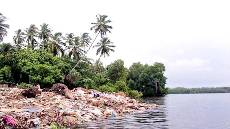
It has been revealed that there are over 10,500 sources of water contamination in the 103 rivers. Many industries have been set up within the river reservation landscapes releasing waste water, human waste, plastics, shopping bags and bottles to rivers. Majority institutions don’t possess environmental permits.
Those who have obtained such permits seem not acting in conformity with environmental protection recommendations. It has been detected that sewage disposal sites were available at some places to collect waste, but when it rains, all garbage flows in to nearby canals leading to rivers causing contamination of river water.
Environmental scientists have submitted to the authorities that the forests in the upper watersheds of most rivers are replaced with tea and other mixed crop cultivations.
Waterways in upper reaches of the rivers get polluted owing to the extravagant use of fertiliser, insecticides and weedicides in cultivations amid a lack of proper soil conservation methodologies. The situation is going from bad to worse due to the removal of timber from riverine environments and invasion of river reservations for constructions. These unwarranted acts cause local floods during the rainy season.
Power generation and agriculture
Mahaweli water has been utilised for power generation and agriculture by constructing dams such as Polgolla barrage (1977), Bowatenna (1981), Kotmale (1985), Victoria (1985, Maduru Oya (1986), Randenigala (1986), Rantambe (1990) and Moragahakanda (2016). Gal Oya, Walawe Ganaga, Yan Oya, Kirindi Oya, Mee Oya, Rambaken Oya, Deduru Oya, and Menik Ganga are some other rivers being used for irrigation by erecting reservoirs under them.
The Kelani river has also been harnessed for power generation. The Kalu Ganga - the largest water source of the country - still remains intact bearing the potential for providing water to the Walawe basin which undergoes severe water scarcity.
The largest flood protection scheme has been constructed in the Gin Ganga basin, with technical assistance of the Chinese Government in 1970. The Nilwala Ganga flood protection scheme was implemented in the 1980s with the French Government offering technological assistance.
Sand mining in rivers has increased with the expansion of the construction industry since the 1990s and has created environmental issues such as banks erosion, collapse of houses, loss of agricultural lands, depletion of water level, degradation of river beds and salt water intrusion.
Mechanised mining is prohibited in rivers under the National Environment Act 47 of 1980. But there are reports that mining continues in rivers violating rules and regulations mainly due to the negligence of law enforcement agencies. Gem mining in rivers is even more harmful to the river bed and its banks. Despite having authorised bodies to prevent such acts, gem mining is continuing.
Referring to the recently launched “Save the river” (Surakimu Ganga) program, Environment Minister Mahinda Amaraweera said that steps have been taken to remove unauthorised occupants and illegal structures along the rivers. The Government will spend Rs. 32 billion for the Surakimu Ganga program.
The Environment Ministry has decided to include 42 new sections in the National Environment Act which has not been amended over 20 years.