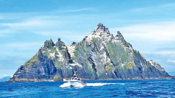
Skellig Michael
Skellig Michael, also called Great Skellig, is the larger of the two Skellig Islands, 11.6 kilometres west of the Iveragh Peninsula in County Kerry, Ireland. A Christian monastery was founded on the island at some point between the 6th and 8th century and remained continuously occupied until it was abandoned in the late 12th century.
The remains of the monastery and most of the island, became a UNESCO World Heritage Site in 1996. Skellig Michael remained in the possession of the Catholic Canons Regular until the dissolution of the Ballinskelligs abbey during the Protestant Reformation by Elizabeth I in 1578.
Skellig Michael was uninhabited before its monastery was founded. Folklore holds that Ir, son of Míl Espáine, was buried on the island and a text from the 8th or 9th century states that Duagh, King of West Munster, fled to “Scellecc” after a feud with the Kings of Cashel, although it is not known whether these events actually took place.
The monastic site on the island is on a terraced shelf 180 metres above sea level and developed between the sixth and eighth centuries. It contains six beehive cells, two oratories as well as a number of stone crosses and slabs. It also contains a later medieval church. The cells and oratories are all of dry-built corbel construction. A carefully designed system for collecting and purifying water in cisterns was developed.

Parc Guell
The Park Güell is a public park system composed of gardens and architectonic elements on Carmel Hill, in Barcelona, Catalonia (Spain). The park was built between 1900 and 1914 and was officially opened as a public park in 1926. In 1984, UNESCO declared the park a World Heritage Site under “Works of Antoni Gaudí”.
Park Güell is the reflection of Gaudí’s artistic plenitude, which belongs to his naturalist phase (first decade of the 20th century). During this period, the architect perfected his personal style through inspiration from organic shapes. He put into practice a series of new structural solutions rooted in the analysis of geometry. In the design of Park Güell, Gaudí unleashed all his architectonic genius and put to practice much of his innovative structural solutions that would become the symbol of his organic style and that would culminate in the creation of the Basilica and Expiatory Church of the Holy Family. The large cross at the park’s high-point offers the most complete view of Barcelona and the bay. It is possible to view the main city in panorama, with the Sagrada Família and the Montjuic area visible at a distance.
The park supports a wide variety of wildlife, notably several of the non-native species of parrot found in the Barcelona area. Other birds can be seen from the park, with records including short-toed eagle. The park also supports a population of hummingbird hawk moths.

Luxor Temple
Luxor Temple is a large Ancient Egyptian temple complex on the east bank of the Nile River in the city today known as Luxor (ancient Thebes) and was constructed approximately 1400 BCE. Unlike the other temples in Thebes, Luxor temple is not dedicated to a cult god or a deified version of the king in death.
Luxor temple was built with sandstone from the Gebel el-Silsila area, which is located in southwestern Egypt. This sandstone from the Gebel el-Silsila region is referred to as Nubian Sandstone. This sandstone was used for the construction for monuments in Upper Egypt as well as in the course of past and current restoration works.
Like other Egyptian structures a common technique used was symbolism, or illusionism. For example, to the Egyptian, a sanctuary shaped like an Anubis Jackal was really Anubis. At the Luxor temple, the two obelisks (the smaller one closer to the west is now at the Place de la Concorde in Paris) flanking the entrance were not the same height, but they created the illusion that they were.
It has been determined that the Luxor temple holds great significance to the Opet festival. The Luxor Temple was dedicated to the Theban Triad of the cult of the Royal Ka, Amun, Mut and Khonsu and was built during the New Kingdom, the focus of the annual Opet Festival, in which a cult statue of Amun was paraded down the Nile from nearby Karnak Temple (ipetisut) to stay there for a while, with his consort Mut, in a celebration of fertility – hence its name.

Faisal Mosque
The Faisal Mosque is the largest mosque in Pakistan, in the national capital city of Islamabad. Completed in 1986, it was designed by Turkish architect Vedat Dalokay, shaped like a desert Bedouin’s tent, is an iconic symbol of Islamabad throughout the world.
It is situated at the north end of Faisal Avenue, putting it at the northernmost end of the city and at the foot of Margalla Hills, the westernmost foothills of the Himalayas. It is located on an elevated area of land against a picturesque backdrop of the Margalla Hills. This enviable location represents the mosque’s great importance and allows it to be seen from miles around day and night.
The Faisal Mosque was conceived as the National Mosque of Pakistan and named after the late King Faisal bin Abdul-Aziz of Saudi Arabia, who supported and financed the project.
The mosque’s unusual design is a departure from the long history of South Asian Islamic architecture, fusing contemporary lines with the more traditional look of an Arab Bedouin’s tent, with its large triangular prayer hall and four minarets. However, unlike traditional masjid design, it lacks a dome. The minarets borrow their design from Turkish tradition and are thin and pencil like.
The shape of the Faisal Mosque is an eight-sided concrete shell inspired by a desert Beduoin’s tent and the cubic Kaaba in Mecca, flanked by four unusual minarets inspired by Turkish architecture.

Atomium
The Atomium is a building in Brussels originally constructed for Expo 58, the 1958 Brussels World’s Fair. Designed by the engineer André Waterkeyn and architects André and Jean Polak, it stands 102 m tall. Its nine 18 m diameter stainless steel clad spheres are connected so that the whole forms the shape of a unit cell of an iron crystal magnified 165 billion times.
Tubes of 3 m diameter connect the spheres along the 12 edges of the cube and all eight vertices to the centre. They enclose stairs, escalators and a lift (in the central, vertical tube) to allow access to the five habitable spheres which contain exhibit halls and other public spaces. The top sphere includes a restaurant which has a panoramic view of Brussels. CNN named it Europe’s most bizarre building.
Three of the four top spheres lack vertical support and hence are not open to the public for safety reasons, although the sphere at the pinnacle is open to the public. The original design called for no supports; the structure was simply to rest on the spheres. Wind tunnel tests proved that the structure would have toppled in an 80 km/h wind (140 km/h winds have been recorded in Belgium). Support columns were added to achieve enough resistance against overturning.

Twyfelfontein
Twyfelfontein, officially known as Ui-IIAis ( jumping waterhole), is a site of ancient rock engravings in the Kunene Region of north-western Namibia. It consists of a spring in a valley flanked by the slopes of a sandstone table mountain that receives very little rainfall and has a wide range of diurnal temperatures.
The site has been inhabited for 6,000 years, first by hunter-gatherers and later by Khoikhoi herders. Both ethnic groups used it as a place of worship and a site to conduct shamanist rituals. In the process of these rituals at least 2,500 items of rock carvings have been created, as well as a few rock paintings. Displaying one of the largest concentrations of rock petroglyphs in Africa, UNESCO approved Twyfelfontein as Namibia’s first World Heritage Site in 2007.
The rocks containing the art work are situated in a valley flanked by the slopes of a sandstone table mountain. An underground aquifer on an impermeable layer of shale sustains a spring in this otherwise very dry area. The area is a transitional zone between semi desert, savanna and shrubland and receives less than 150 mm annual rainfall.
Sandstone rocks at Twyfelfontein are covered by the so-called desert varnish, a hard patina that appears brown or dark grey. Engravings were affected by chiseling through this patina, exposing the lighter rock underneath. The indentations were created over thousands of years. The oldest engravings might be as old as 10,000 years and the creation of new works probably ended by the arrival of pastoral tribes around 1000 AD.